By far the largest part of Kazakhstan is in Central Asia, only a small part of the country belongs to Europe. Bordering countries are Russia, China, Kyrgyzstan, Uzbekistan and Turkmenistan. Most of the country, with the capital Astana, consists of steppe, the sand massifs of the Karakum and the vast desert of Kisilkkum. The Aral Sea and Lake Balkhash are the largest bodies of water in Kazakhstan. The main cities are Almaty, the former capital and Baiqongyr, where the largest space airport in the world is located.
Interesting travel destinations in Kazakhstan are the Siebenstromland and the lli delta as well as the Charyn Canyon and the Aksu Jabagli nature reserve. Lake Aral is located in the west of the country. The Kurgaljino nature reserve in northern Kazakhstan is home to the world’s northernmost population of pink flamingos. A particularly unusual attraction is the Singing Barkhan, a sand dune in the desert that is several kilometers long and about 80 centimeters high and gradually disintegrates in its movement. This creates a sound that sounds like loud vocals.
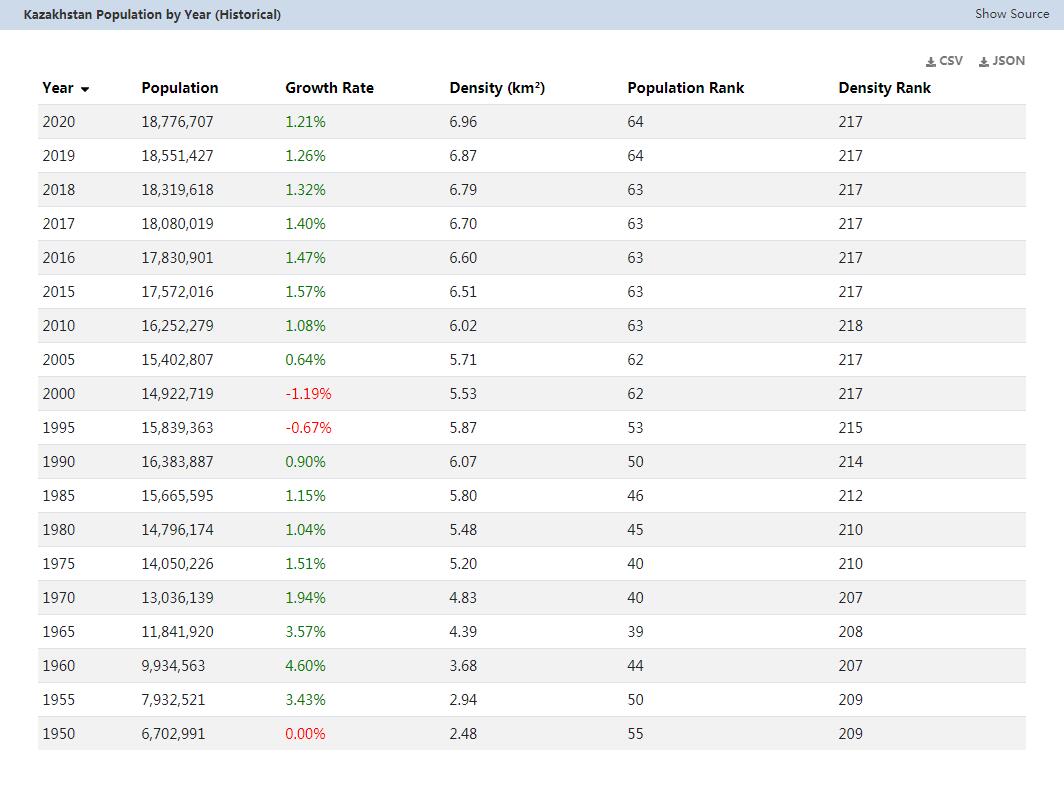
In 1991 the population of Kazakhstan suddenly fell sharply. The residents left the country mainly due to high unemployment. From 1992 to 2002, the population dropped by a total of 10 percent.
Another reason for this massive decline was a decline in the birth rate. This wave of emigration ended in 2003 and the numbers slowly increased again. Since then, more babies have been born and the population in Kazakhstan has now increased to 15.4 million people.
The population distribution in Kazakhstan is quite uneven. Most people live in the extreme south and on the right bank of the Irtysh in the north. But even the most densely populated part of Kazakhstan only has an average of 25 inhabitants per km².
Area: 2,724,900 km² (land: 2,699,700 km², water: 25,200 km²)
Population: 15.5 million people (July 2011, COUNTRYAAH.COM). Kazakhs 53.4%, Russians 30%, Ukrainians 3.7%, Uzbeks 2.5%, Germans 2.4%, Tatars 1.7%, Uygurs 1.4%, others 4.9% (1999 census).
Population density: 5.7 inhabitants per km²
Population growth: 0.4% a year (2011, CIA).
Capital: Astana (351,340 inhabitants, 2006)
Highest point: Khan Tangiri Shyngy (Pik Khan-Tengri), 6,995 m
Lowest point: Vpadina Kaundy, -132 m
Form of government: Kazakhstan has been a presidential republic since 1991. The constitution dates from 1995, the last constitutional change was made in 2007. The Kazakh president is elected for life. The bicameral parliament consists of the lower house ( Maschlis ) with 77 members and the Senate with 39 members. Kazakhstan achieved independence from the Soviet Union on December 16, 1991.
Administrative division: 14 provinces (oblystar, singular oblys): Almaty Oblysy, Aqmola Oblysy (Astana), Aqtobe Oblysy, Atyrau Oblysy, Batys Qazaqstan Oblysy (Oral), Mangghystau Oblysy (Aqtau), Ongtustik Qazaymodarysysy (Aqtau), Oblysy, Qostanay Oblysy, Qyzylorda Oblysy, Shyghys Qazaqstan Oblysy (Oskemen), Soltustik Qazaqstan Oblysy (Petropavlovsk) and Zhambyl Oblysy (Taraz)
3 cities (qalalar, singular: qala): Almaty Qalasy, Astanaongal
Prime Minister: Prime Minister Serik Nyghmetuly Akhmetov, since September 24, 2012
Head of state: President Nursultan Nazarbayev, since December 16, 1991
Language: The official language in Kazakhstan is Russian and is spoken by 95% of the population. The national language is the Turkic language Kazakh (spoken by 64.4% of the population).
Religion: Muslims 47%, Russian Orthodox 44%, Protestants 2%, others 7%
Local time: East Kazakhstan (Astana, Almaty): CET + 5 h.
No changeover between summer and winter time.
The time difference to Central Europe is +5 h in winter and +4 h in summer.
Central Kazakhstan: CET + 4 h.
No changeover between summer and winter time.
The time difference to Central Europe is +4 h in winter and +43 h in summer.
West Kazakhstan: CET + 3 h.
No changeover between summer and winter time.
The time difference to Central Europe is +3 h in winter and +2 h in summer.
International dialing code: +7
Internet ID:.kz
Mains voltage: 220 V, 50 Hz. Round, two-pin plugs are used
Population in Kazakhstan
This map of the population distribution in Kazakhstan was created by the Worldmapper team. Densely populated areas appear bloated, the area of sparsely populated areas is reduced. The shape of the grid has been preserved; an underlying map with the original geographical extent helps interpret the map. The distorted map should help to present abstract statistical information clearly.