Lebanon is about 217 km long and 40 to 80 km wide. A narrow plain stretches along the coast of the Mediterranean Sea. The inland territory is dominated by two large mountain ranges separated by the fertile Bekaa Valley. The Lebanon Range, cut by a large number of deep gorges, rises steeply from the coastal plain and to the north is the highest elevation in the country, Qurnat as Sawdā ‘(3,088 m). The other great mountain range, the Anti-Lebanon, lies to the east, along the border with Syria. The largest river in Lebanon and the only navigable river, the Litani, flows through the Bekaa valley.. Most of the remaining rivers only carry water during the winter rainy season. Cuneta also with the Jeita Grotto, nominated to be one of the Seven Natural Wonders.
Climate
The climate varies from a subtropical Mediterranean type along the coast and in the Bekaa Valley, to a rather cold one in the higher mountains. Summers are hot and dry; mild and humid winters. Frosts are rare at lower altitudes. The average temperature in the lowlands is 26.7 ° C in summer, and 10 ° C in winter. The mountainous region is somewhat colder. The annual precipitations take place mainly in the winter; on the coast they are 889 mm, while in the Bekaa valley they are 635 mm, and in the mountains they are more than 1,270 mm.
Flora and fauna
Most of Lebanon has been deforested. In the mountainous areas there are still forests of oak, pine, cypress and the famous cedars of Lebanon. In most of the different areas there is a Mediterranean scrub vegetation with some trees. Some species of wild animals still survive such as jackals, wolves, wild asses and gazelles.
Soils
Most of Lebanon has a reddish brown soil called terra rossa. Along the coast, in the Bekaa valley and in the northeast, there are richer alluvial soils. However, erosion is very important, and the mountainous areas are rocky and barren.
Natural resources
Except for some fertile soils and what remains of the forests, Lebanon’s natural resources are unimportant. There is iron ore but it is difficult to obtain; it also has small amounts of other minerals such as coal, copper, and phosphates.
Environment
Lebanon’s environment was seriously affected during the civil war, which lasted from 1975 to 1990. During the conflict, ecosystems were destroyed, environmental regulations were not respected and conservation programs were abandoned. After the war, most of the government’s efforts were aimed at recovering the country’s basic infrastructure. However, in recent years, Lebanon has increased its commitment to cleaning and preserving the environment.
Before the civil war, Lebanon was an important commercial, financial and industrial center. This productivity had environmental consequences, such as pollution derived from the uncontrolled discharge of sewage and industrial waste. Untreated waste was dumped into waterways or dumped into deep wells, sometimes contaminating underground aquifers. Solid toxic waste was deposited in municipal landfills without prior treatment processes. Although the Lebanese government is striving to implement waste dumping methods that are safer from an environmental point of view, many industries continue to pollute waterways and coastal areas.
The gasoline sold in Lebanon has a large amount of lead, which contributes to air pollution, especially in urban centers. The country’s electricity generation plants pollute the atmosphere by burning fuel. In 1998, Lebanon announced a plan to use natural gas instead of fuel as the cleaner fuel to generate its electricity.
As a country located in Asia according to ETHNICITYOLOGY, Lebanon has the highest population density in the Middle East, with an average of 388 residents / km² in 2008, and the irregular development of cities threatens the undeveloped areas of the country. As a consequence, soil erosion and desertification have increased in recent years.
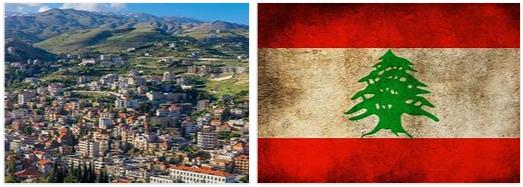
The cedar forests of Lebanon were very famous in ancient times, but intensive logging over the centuries has reduced the wooded area to a fraction of its original extent. The cedars of Lebanon have been cited in the Bible and other works of ancient literature and continue to be a benchmark of national pride. In fact, the flag of Lebanon features a cedar.
In 1997, Lebanon established the Al-Shouf cedar reserve, which occupies 5% of the national territory. Although cedar trees cover a small percentage of the reserve, conservation groups are trying to increase their population in other areas of the park. The Lebanese government has planned the creation of other parks and reserves.
Antipersonnel mines and other unexploded ordnance, abandoned during the civil war, continue to pose a threat to animal and human populations. In 1998, the United States agreed to provide Lebanon with the technical and financial assistance necessary to clear the antipersonnel mines still present in the country.
Lebanon has ratified international agreements aimed at protecting biodiversity and the ozone layer. It has also signed treaties limiting hazardous waste, nuclear testing, and marine pollution.
Anti-Lebanon
Eastern Mountain, a 145 km long mountain range located southwest of Syria and east of Lebanon. It constitutes a large part of the border between these two countries. It stretches from north to south from the plain around the Syrian city of Homs to Mount Hermon. To the west is the Lebanon mountain range, separated from the Anti-Lebanon by a fertile valley, the former Coele-Syria (now Bekaa) that stretches across Syrian and Lebanese territory.
The city of Damascus in Syria, and that of Beirut in Lebanon, are connected by road and rail. Some geographers refer to the two mountain ranges together as the Líbanos. The Antilíbano is sparsely forested, and to the north it becomes arid and rocky. The highest peaks are Mount Hermon (2,814 m), where the Jordan River is born, and Tal at Musa (2,669 m). To the east of the Antilíbano is the Helbun valley, where the city of the same name that appears mentioned in the Old Testament was located.
Lebanon mountain range
Southwest Asian mountain range. It stretches along the Mediterranean coast from southern Lebanon into Syria. The Qurnat as Sawda ‘ is the highest peak of the mountain range with an altitude of 3,083 m above the level of the sea. In ancient times, the steep slopes were covered with cedars of Lebanon.
A series of underground springs, on the lower slopes of the mountain range, allow the cultivation of apple, pear and peach trees, considered as valuable fruit trees in the arid Middle East. In the 7th century these mountains served as a refuge for religious communities, among them the Maronites that still remain. Today they are the largest Christian group in Lebanon.
Bekaa Valley
Fertile valley of Lebanon and Syria. It stretches along the Litani and Orontes rivers, between the Lebanon mountain range to the west and the Anti-Lebanon to the east. Located approximately 30 km east of Beirut, the Bekaa Valley is the northernmost tip of the Great Rift Valley, which stretches from Syria through the Red Sea to Africa. It has a Mediterranean climate with mild, rainy winters and hot, dry summers.
The region has little rainfall, mainly in the north, since the Lebanon mountain range produces the effect of rain shadow by preventing the humidity-laden winds from the sea, which are the ones that produce precipitation. The average rainfall in the northern zone is 230 mm while in the central part of the valley it is 610 mm.
Since the 1st century BC, when the region was part of the Roman Empire, the Bekaa Valley was the source of grain for the Roman province of Syria. Today, the valley represents more than 40% of Lebanon’s arable land. The north of the valley, with little rainfall and not very fertile soils, is used mainly as grazing land by nomadic herders. Further south, the more fertile soils produce crops of wheat, corn, cotton, and legumes, with vineyards and orchards sprawling around Zaḩlah.
The Litani hydroelectric project, a series of canals and a dam located in Al Qir’awn, on the southern edge of the valley, has favored the extension of irrigation to farms in the Bekaa valley. Zaḩlah, the largest city in the Bekaa Valley, is located north of the main road between Beirut and Damascus, which divides the valley into two parts. The most important historical site in the valley is Baalbek, an ancient city named after the Canaanite god Baal.
Baalbek contains impressive Roman ruins, including the temples of Bacchus, Jupiter, Venus, and the Sun. For many years, the ruins were the scene of the Baalbek festival, attended by theater groups from around the world. The Bekaa Valley has witnessed fighting between Syrians and Lebanese and between the forces of the Palestine Liberation Organization and Israel.